
Ngerulmud (Palauan pronunciation: [ŋəˈɾulmuð]) is the seat of government of the Republic of Palau.
My decision to visit four Micronesian countries in 2024–25 was driven more by convenient flight options and a growing affection for the Pacific Islands than by any deep understanding of each nation’s history or culture. When Nauru Airlines announced it would extend its island hopper service for another year and Qantas launched its new Brisbane to Palau route, the ‘Palau Paradise Express’ suddenly, Palau became much more accessible. With both routes available, I had two viable options, and Palau no became ‘hard to travel’. Since I had Qantas Frequent Flyer points to use, I opted for the Qantas route to start my journey and was pleasantly surprised to find I could begin my travels from Bendigo Airport, avoiding the peak-season crowds and high fares in Melbourne just after Christmas.

A reconstructed Bai (men's meeting house) in the yard of the National Museum.
Upon arriving in Palau, visitors are not subject to the usual visa procedures. Instead, they must sign a pledge, making Palau the first country in the world to implement such a requirement in support of environmental conservation. This pledge commits travellers to behave in an environmentally and culturally respectful manner during their stay, for the well-being of Palau’s children and future generations. The Palau Pledge states:
"Children of Palau, I take this pledge as your guest, to preserve and protect your beautiful and unique island home. I vow to tread lightly, act kindly, and explore mindfully. I shall not take what is not given. I shall not harm what does not harm me. The only footprints I shall leave are those that will wash away."
This was administered by a small middle-aged woman who spoke politely and thanked me graciously, possibly the most welcoming arrival to a country I have received. Full of happiness endorphins, I headed into arrivals and expected, as is typical at most airports, to be swamped with taxi offers. My hotel did not offer airport transfers but assured me that I could get a taxi there, but this was not the case at night! After about ten minutes, most visitors had disappeared with their various transfers and, along with one other tourist I was left standing, wondering how I was to get to the hotel. The roads were dark and empty, and the hotel was too far to walk to; sleeping in the airport was not even an option as the doors were promptly closed and locked. Fortunately, an airport staff woman, who had been trying to phone taxis for us, offered to drive us to our hotels. Some children playing on skateboards in the carpark turned out to be hers and they jumped into the back of the van while we were transported to our accommodations. I paid her what I had been quoted for a taxi, she seemed more than happy and my faith in humanity was restored. Having travelled from early in the morning and arriving late at night meant that I had not seen sunlight all day and so when I was taken to my downstairs hotel room, at first, I found it dark and depressing. However, the darkness of the room turned out to be a bonus as I slept soundly every night and morning with no sunlight to wake me.
First night aside, luck followed me during this trip as I managed to meet many people, which led to dinners and drinks together, hire car excursions and the lively sharing of travel stories and philosophies. Some might find it hard to believe but I am quite shy and find it an effort to strike up conversations with strangers, but that is changing as I am making travel a priority. By eavesdropping on the Brisbane to Palau flight the day before, I had heard a curious Australian tourist conversing with the people next to him who turned out to be diplomats, living in Palau. As the plane was more than half empty the tourist moved to the window seat adjacent to my aisle seat. The next day I ran into the tourist (Mike) and his brother, Brett in a coffee shop; we must have read the same recommendations for places to go for coffee, and in their case breakfast. Whilst I was surprised and thrilled to learn that I was able to order an almond milk coffee, my hopes were somewhat dashed when I discovered that the Palau coffees are large and super strong (heart palpitations remained for the rest of the day) and made with runny sweetened almond milk (all milk is long life and imported so I can’t blame them) but at least it was coffee. After we went our separate ways, I sought out the traditional museums, admired the beautifully painted bais (meeting houses) and explored the residential neighbourhoods, dodging growling dogs and mummified toads on the roads, and at the end of the day ended up at another popular spot, The Canoe House, which seemed like a good place for a refreshment and maybe dinner. Fortuitously, I again ran into Mike and Brett, onto their third beer and full of joviality, and we dined together whilst debating the big and small issues of the world and discussing our planned excursions for the week; Brett was heavily into diving and Mike was intending to explore every other type of day tour from flights over islands to snorkelling.


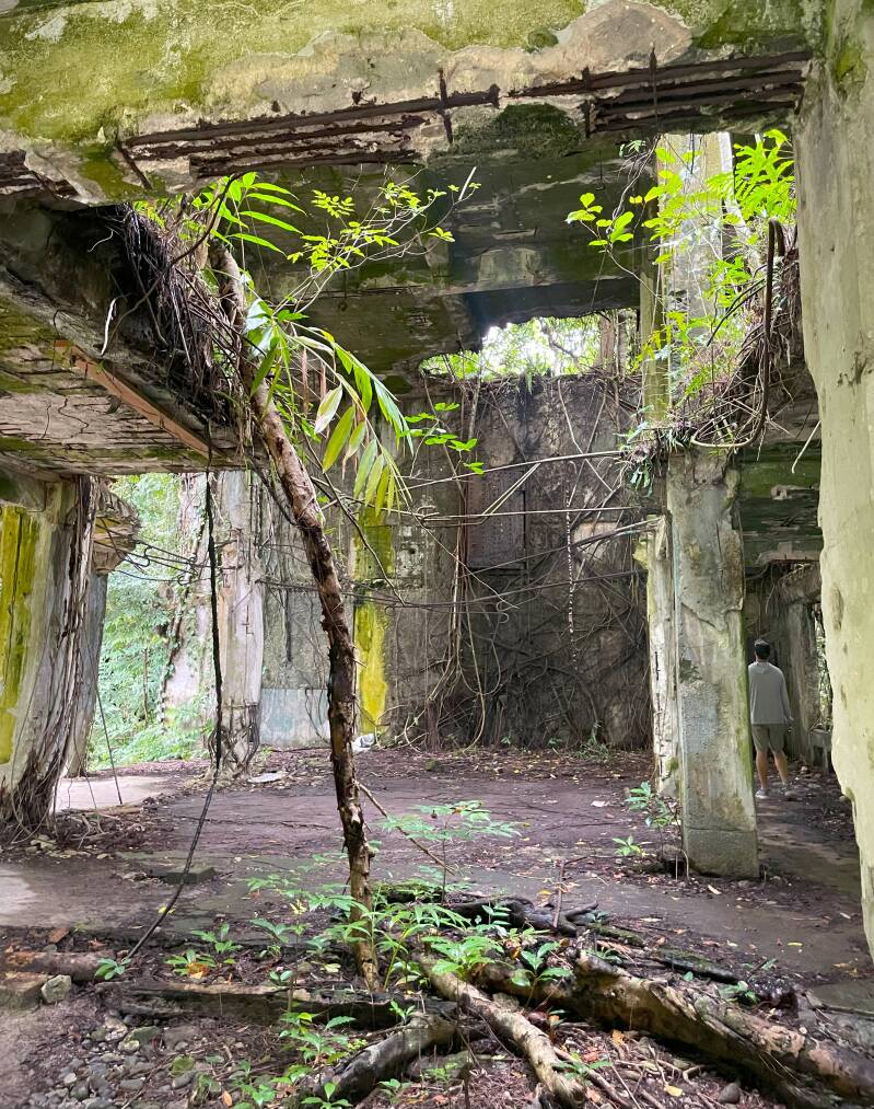
Views of a Japanese Food Storage Bunker in Peliliu Island, Palau
For a small country of 17,727, (the fourth smallest country in the world in terms of population), Palau is spoilt for choice with tour companies, and I settled on IMPAC, a Japanese run company and booked two tours, the first being a boat trip and tour of Peleliu Island, famous for being the site of a WWII battle between US and Japanese troops. Our lively (not Japanese) tour guide Grant spoke excellent English and constantly reminded us to ‘Watch your head’ every time we got in and out of the boat; the Japanese tourists got their own guide and boat and our group of around 8 tourists from Guam, the US and elsewhere donned life jackets and breathed in the fresh sea air and sumptuous island and sea views as the boat motored along.
Peleliu island was the site of a World War II battle between U.S. and Japanese troops, now marked by rusted military remains in the island’s rocky caves and forests, as well as underwater shipwrecks. The island is where the fiercest battles with the US military took place during World War II. There are many battle sites on the island that give us a glimpse into the fierce fighting that took place at the time.
Peleliu was held by a garrison of more than 10,000 Japanese troops. The island's airfield would allow Japanese planes to threaten any Allied operation in the Philippines, and General Douglas MacArthur pushed for an amphibious attack in order to neutralize this threat.

Japanese army tank at Orange Beach Cemetery, Pelilu
The Battle of Peleliu resulted in the highest casualty rate of any amphibious assault in American military history: Of the approximately 28,000 Marines and infantry troops involved, 40 percent of the Marines and soldiers that fought for the Island died or were wounded, for a total of some 9,800 men (1,800 killed in action and 8,000 wounded).
The Japanese fought to the very end. Only 202 out of 11,000 troops survived with a group of 35 Japanese soldiers hiding out in the caves of Peleliu, for 18 months before surrendering in April 1947. We got to visit several of the caves around what was known as Bloody Nose Ridge. The largest man-made cave here was home to a few thousand soldiers and still are old sake bottles and personal bowls laying around in the cave, old remains from the battle of Peleliu.
We visited the remains of the former Japanese military headquarters, air raid shelters, tanks and cannons, and the US military's amphibious tanks. Many of these sites still bear bullet marks from the offensive and defensive battles.

IMPAC Guide Grant explaining the mass burial site
We also visited a mass burial site where the remains of Japanese soldiers have been recently located. Japan’s Health, Labor and Welfare Ministry were about to exhume the bodies, 1086 of which were buried there.
In October 2023, the association found an area in the densely forested central part of the island where iron stakes had been driven into the ground at equal intervals as if to delineate a 900-square-meter area.

Hiking the Jungle Trail in Peliliu Island

Japanese cave based artillery

Remains of the Japanese Millitary Headquarters
Inside the Japanese Military Headquarters at Peleliu; the roof is collapsing and entry upstairs is (supposedly) forbidden.

Another of the many studies in light and texture of the Japanese Military Headquarters in Peleliu
As we headed back to our boat, I orchestrated a group photo in front of the iconic Peleliu sign as a memory of our journey and camaraderie. Our jovial picture sharing was abruptly interrupted by our leader Grant, dramatically insisting that we hold our life jackets in front of us to ward off the coming rain; given the small size of the boat, I considered it more sensible to actually wear the life jacket (um, that’s what they’re for!) so that I had free hands to grasp the boat as it rocked heavily against the storm. Considering what we had just learnt about the challenges soldiers on both sides of the battle of Peleliu endured, none of us were particularly worried at being battered with waves and soaked to the skin.

Yours truly at Carp Island during the Rock Island tour
I returned with IMPAC two days later for another excursion, this time the quintessential ‘Rock Island Snorkelling’ which was more of a ‘something for everyone’ tour with snorkelling, visits to ‘Long Beach’ (not to be confused with Long Island Beach; that’s another story), the German Channel, considered a passageway for Manta Rays, a visit to Carp Island for a BBQ lunch and ‘Milky Way’, a natural lagoon with white clay mud that is collected in a bucket and used by the visitors to cover their body; it is purported to have therapeutic qualities and (I only read this later) to make you look ten years younger. Perhaps I should have kept it on my body longer as I looked just the same, post mud pack. Feeling the white clay reminded me of my ceramics days and I asked our guide what sort of clay it was; he looked puzzled, to which I prompted ‘Bentonite? Feldspar? Ball Clay?’ No answer from the guide but from online research I learnt that it is limestone, so therefore CaCO₃ (Calcium Carbonate); I can’t believe I have found a practical use for my studies in Chemistry in First Year! I am confident that the predominantly Japanese cohort were not concerned about the chemical formula as they smeared themselves with thick clay and took thousands of selfies. The next stop was the actual snorkelling during which I was one of the few participants to eschew wearing a life jacket and even the snorkel mouthpiece, preferring to hold my breath as long as possible. Whilst there was good visibility with a variety of fish spotted, the visit was merely a whistle stop as we headed back to the boat and onwards to Carp Island for lunch; on the way back, we stopped at German Channel, so called because it was made by the Germans during the time when Palau was a German Colony. The artificial channel was created after 1905 when it was discovered that phosphate could be found from the guano, or excrement from seabird, cave-dwelling bats and seals. The Germans blasted and dredged a channel through the barrier reef to allow the phosphate to be moved to port for shipment to Europe. Originally sourced from Peru in the 1840’s guano was sought after as a fertilizer and in some cases refined for gunpowder. It was so high in demand that in 1856 the US Government created the Guano Islands Act which allowed any US citizen to claim any unclaimed island rich in Guano and for that island to immediately become a US territory.

Standing in German Channel at High Tide

Heading out to sea in the Rock Islands
We were warned that Long Beach might be under water if the tide is too high but that did not stop most of our boat load who were happy to wade over to the raised strip to mark the ‘walking on water’ moment with selfies. Later that week I visited another Long Beach, the nearby Long Beach Park, which is free, visited by locals and allowed clear snorkelling in the shallow waters.
With only a day left of my one week stay in Palau, I was relieved to hear again from Mike who had hired a car and intended to drive around Babeldoab island with new acquaintance Col, inviting me to join them. I was excited at not only the chance of company but the opportunity to visit at least ten cultural and nature sites identified on both Palau’s delightful, illustrated map and the Nomadmania app. I rarely collect hard copy maps these days but this one included pleasing three dimensional drawings of the buildings and other sites to look out for and as a former Visual Communication teacher, I always appreciate a good two-point perspective or isometric.

It might not be the most spectacular looking bridge but, the Palau-Japan Friendship Bridge holds significance.
Heading north towards the capital, we passed by the Japan-Palau Friendship Bridge which is the main artery connecting the country’s two main islands: Koror Island, home to the former national capital (also called Koror), and Babeldaob Island, the largest island in the country, where the airfield, power station, and other major facilities are located. The original bridge was built in 1977 but in 1996, the bridge collapsed, resulting in several fatalities. Besides being the primary means of transportation between the two islands, the bridge carried electrical and water lines from Babeldaob to Koror. The collapse severely disrupted the infrastructure of the city of Koror, where 70 percent of the population of Palau resides, and dramatically affected their daily lives and their primary industry—tourism. The government of Palau installed a floating bridge as a temporary replacement and at the same time asked Japan to help build a new bridge. Japan responded by providing grant aid for the construction, which began in November 1999. The new bridge was completed six years later, in 2002. The people of Palau named it the Japan-Palau Friendship Bridge, and a plaque with the name inscribed was placed at each end.

Kaigun Sho, the ruins of a WWII Japanese Communications Centre
Directly over the bridge, we stopped at another WWII ruin, Kaigun Sho, the ruins of a Japanese Communications Centre. It was built in the shape of a cross and disguised as a field hospital to avoid being attacked, although eventually the allies discovered their trick and bombed it. We could see various remnants from the war, including tanks and guns. A sign indicated that you needed to buy a ticket from the Airai State Office or risk getting fined 500 USD but there was no one around to collect a ticket so we visited gratis.

Airai Bai, Palau's oldest bai (men's meeting house)

Detail of Airai Bai, with delightful Money Bird hand painted designs.

A painted coconut head decorating the war canoe Kaekl.
Our next stop was Airai Bai, Palau's oldest bai (men's meeting house). Over 100 years old, it was constructed using local materials of wood and thatch on a stone platform. Legendary scenes and symbolic motifs are painted inside and outside. The delerrok, a mythical money bird, was illustrated at all four corners of the bai; it was thought to bring good fortune to the village. Next to the Bai was a spectacular war canoe, Kabekl, which was built in the 1990s by some of the elders of Airai and some of younger man who are involved in man’s association in the village. These canoes can accommodate 40 people, and the man who we met there said that the canoe had actually been used.

Beautifully decorated war canoe, Kabekl

Checking out the Palau Baptist Church; it was locked so I was unable to enter! slight edit fail!
My Nomadmania app had indicated the nearby Palau Baptist Church which I assumed must have great significance to be included, so I was somewhat perplexed when we found ourselves up a small side street in front of what was certainly the Palau Baptist Church, complete with signage, but was somewhat small in scale, with its exterior covered in mould. The Palau Baptist Church does have a Facebook page but no images of the actual building so this one will have to remain a mystery.

The Capitol Complex architecture juxtaposes classical style architecture alongside traditional symbols of birds and patterns.
By complete contrast, our next visit made us think we’d been transported to another country with an obvious huge amount of government funding spent on buildings and infrastructure. We had arrived at the Capitol Complex of Ngerulmud, in the region of Melekeok, capital of Palau since 2006, with a population of 390 people. The population of Negermulmud is….0, making it the least populated capital city in the world.

The centrepiece of Ngerulmud is its grand capitol complex, which began planning in 1986 and was officially opened in October 2006. The complex cost over US$45 million to construct (partly through a loan from Taiwan) and includes buildings for the legislative, executive, and judicial branches of government. A central open plaza connects these structures, creating an architectural focal point for the small city. The design of the complex reflects both modern and traditional Palauan elements, making it a symbol of the nation's identity. As we wandered around the complex we fully expected armed guards to emerge and tell us to leave but we barely saw any people except for maintenance workers and gardeners, probably because, as we learnt later, the capital was previously in the island of Koror and staff did not want to relocate. Palau had only gained independence from USA in 1994, hence the idea of creating this new capital, but the complex has been seen as a failure due to its isolation with staff only commuting for work or even staying in Koror.
The capital city has hosted international events like the Pacific Islands Forum and has its own postcode, setting it apart from the rest of Palau.

Selfie for scale: The Korean Memorial Park
Our next stop, the Korean Memorial Park ('한국인 추념공원') required navigating past an inconspicuous entrance and walking up a muddy pathway. We appeared to be met with suspicion by some local men offloading something from the back of their ute but considered it safe to continue. Through long untamed grass, we hiked up a small hill to a cluster of memorials and statues. During the Japanese presence in Palau, many Koreans were conscripted there as labourers and many died during the war. The most prominent monument, an obelisk with a dove, commemorates their lives and sacrifice.

Beautiful orchids surrounding the Korean Memorial site.
On the way back I requested a stop on the road so that I could photograph some of the orchids blooming there. Col, his long hair flying, oblivious to any possible dangers in the jungle danced into the bush barefoot while I carefully trod through it in my ankle high hiking boots; Mike eschewed the walk altogether as his legs were still hurting from post-snorkelling sunburn. ‘I haven’t quite worked Col out.’ Mike concurred.

Delightful sculptural details in the Korean Memorial Site.
One of the most significant spots on the Babeldoab map is the Stone Monoliths of Badrulchau, sometimes known as the Easter Island of Palau. This sacred ground is home to 52 ancient basalt megaliths lined up in two rows, dating back to 161 CE. According to traditional Palauan belief, these monoliths were revered as sacred prayer grounds, a place where earth met the divine. Some of the stones had carved faces with huge, bulging eyes and prominent foreheads.

The Stone Monoliths of Badrulchau
The most common theory for their existence is that the stones may have stood tall as pillars supporting a bai, the ancient Palauan meeting house. Therefore, these monoliths could be the vestiges of the grandest bai ever constructed.
When we arrived at the entrance, we were faced with an entry fee and a series of steep stairs. Budget traveller Col decided to forgo the fee and therefore the visit to the most significant archaeological site in Palau in favour of smoko time, and Mike, whose legs were still flaring up, decided to brave the steep stairs and we visited together.


Enthused after having visited such a significant archaeological site, my anticipation was building at visiting another archaeological site, at the very north of the island, Tet el Bad, (Stone Coffin). We drove backwards and forwards along a road, expecting some major signage until I decided to walk up the small hill following the app’s map. What I saw at the top of the hill was initially an underwhelming group of rocks but I was to learn that there was significance to both the coffin and its location. Tet el Bad is part of a tentative list of Palau objects hoping for inclusion in the World Heritage List. The Stone Coffin is very small at 233cm by 66cm, at a height of 40cm. It was previously moved for research to a museum in Koror in the 1930s. It stayed there until the 1980s, when it was transported back to this place of origin. Tet el Bad (Stone Coffin) is constructed from volcanic andesite rock with carvings and is located on a stone platform near the chief’s meeting house in Ollei traditional village in northern Palau.

Tet el Bad, (Stone Coffin) back to its original site, in a residential area.
Next stop was a Japanese Lighthouse and Outpost. Todai is the Japanese word for Light House, hence its title. Evidence of previous gunfire was shown in the pock marked buildings and the views were magnificent; it is easy to see why this location was chosen. The area was also the location of the general living quarters of a general.

Remains of the Japanese Lighthouse

Bullet holes in the Japanese Lighthouse

Next to the Japanese Lighthouse
The small hire car would be unlikely to pass any roadworthy tests in Australia but it successfully transported our motley crew of travellers around the stunningly green and clean Babeldoab island with its saturation of culturally significant sites.
As my week in Palau came to a close, my only regret was missing the chance to visit the Palau jail, where inmates guide visitors through a shop selling beautifully carved wooden storyboards, a remarkable initiative that blends rehabilitation with cultural craftsmanship. Sadly, photography wasn’t allowed in the two museums I visited, where storyboards were also displayed, so I leave without any visual keepsakes of these extraordinary artifacts, but their impression will stay with me nonetheless.

Locals swimming in the confusingly named Long Island Park, in Koror, which had surprisingly good snorkelling!
Create Your Own Website With Webador