
View from Mangrove Bay Hotel, Pohnpei
‘Look at this jungle. Look at the vines, the way they twine around the trees, swallowing everything. Nature's cruel, Staros.’ Lt. Col. Gordon Tall, played by Nick Nolte in The Thin Red Line 1998 film

Aerial view of the islands surrounding Pohnpei.
For the next leg of my Micronesian journey, I boarded Nauru Airlines’ famed “Island Hopper” route. I’d pre-selected my seats for the next three flights online and was thrilled to find myself in the third row, with no one seated nearbyall at an economy fare. When we landed in Pohnpei, the most populous of the Federated States, only three passengers disembarked—including me. I later found out that the rest were continuing on to the Marshall Islands (my stop the following week), Kiribati, Nauru, or Brisbane.
Surprisingly, the airport was eerily quiet for mid-morning. No taxis. No bustling terminal. I had arranged an airport transfer through my hotel via email, but after receiving no reply for several days, I was left stranded. A large sign in the terminal promising travel SIMs offered false hope—it turned out they no longer sold them, yet hadn’t taken the sign down. Eventually, I pleaded with the only airport staff I could find to call a taxi. The short ride into town cost the standard US$5, but the driver took my $10 and offered no change. Welcome to the Federated States of Micronesia, I laughed to myself.


View from Ocean View Plaza Hotel and a traditional meal from the menu.
At least I was able to check in early to my hotel which had possibly the best view on the island, looking down to the ocean on one side and Sokeh’s Mountain on the other. The hotels’ title of Ocean View was no misnomer.
I was soon to discover that possibly the best food in the country was only a 10-minute walk downhill. Mangrove Bay Hotel and Restaurant sold the best sushi and sashimi on the island – but that’s only if the chef turned up; if not, there were still basic salads and burgers and on one occasion I enjoyed a spectacularly delicious seafood salad. Mangrove Bay was also the location of one of the main tour operators, Pohnpei Surf Club, which I visited to see if I could join in with any group tours that week. If you are reading this thinking “this is the first time I have heard of the Federated States of Micronesia”, then you can imagine how few tourists visit the country, and therefore how difficult it might be as a solo traveller to find a tour with people already booked in. However, I was contacted a day or so later as a couple had booked in for the coveted Nan Madol excursion and that meant I could join in without having to mortgage my house for the cost of the tour.

Sokeh's Rock
My second day in Pohnpei was a Sunday, which I knew meant that most businesses would be closed and church going would take precedence. Intrigued by the rock in the hill on the distance, I learnt that its name is Sokeh’s Hill and that I could hike to Sokeh’s Ridge, just past the local church.

The local church, so full that many of the community are forced to stand outside.
Sokeh’s Island is historically significant for its role in the 1910 Sokehs Rebellion against the German colonial government and was one of several locations around Pohnpei heavily fortified by the Japanese prior to World War II. The island is also notable for its many outer-island residents, people of Pingelapese, Mwoakillese, Ngatikese, and Mortlockese descent who were allowed to settle in Sokehs in the early 1900s.

Thoughtful signage along the way to Sokeh's Ridge.
A Bridge over troubled waters?
As I set off toward the Ridge, my journey nearly ended before it even began. To reach the other side of the road where Sokeh’s Island starts, I had to cross a small bridge just beyond the church, but it was overrun with dogs. They snarled and paced aggressively as I approached, making it clear I wasn’t welcome.
Recalling all manner of bridge metaphors in film and philosophy distracted me from their hostility and the possibility of their attack. In the Australian TV mini-series The Glitch, a bridge is used to delineate the ‘The Boundary’, an invisible barrier which prevents those that have risen from the dead from escaping the town. The subject of the 1957 film and novel, the bridge from The Bridge on the River Kwai, is a part of the Burma Railway, and holds immense significance as a symbol of human resilience and the suffering endured during World War II. Its construction by Allied POWs and Asian labourers under brutal conditions resulted in immense loss of life. The bridge is a poignant reminder of the atrocities and the enduring human spirit. Rather than hurling rocks or carrying a stick as some have suggested, I just hurried ahead, pretending that the dogs were not there and before I knew it, I had safely reached the other side.


Abandoned cars on the road on the way to Sokeh's Ridge.
Sokehs Mountain or Pohndollap, which means ‘on the big hill,’ is a ridge of Sokehs Island. The mountain was a refuge for the insurgents of the Sokeh’s Rebellion and later a key location in the Japanese defence of Pohnpei during World War II. The mountain’s attractions are mostly war-related, though it is also a birding spot.

The pathway along Sokeh's Ridge up towards the Japanese Artillery and lookout area. Note the ominous sky.
As I wandered around the hilltop, I came across scattered remnants of history, rusting anti-aircraft guns, rifle pits, and the pockmarks of old bomb craters. My path was soon limited; without a machete (a hiking essential I would only learn about later), the overgrowth became too dense to continue. Just then, the skies opened, and rain began to pour, driving me to take shelter inside the old Anti-Aircraft Battery.


A poignant sign explaining the role of women during the war and how difficult it was for locals being caught up in a war that was not theirs.
Huddled inside, I couldn’t help but reflect on what it must have been like to be stationed here for days at a time, isolated, exposed, and alert. Yet, in that moment of solitude, I felt a strange privilege. I was entirely alone, surrounded by the haunting silence of history, with an uninterrupted view of the ocean meeting the jungle, a breathtaking contrast to the site's violent past.

View from inside the Japanese WWII Shelter during the rain.

A view of the archipelago from Sokeh's Ridge.
In 1944 the US heavily bombed the island aiming to destroy the military capability of the Japanese. There were very few Pohnpeien casualties because of the fact they weren’t allowed near those installations. The airport was destroyed to remove the ability of air cover from here and the big guns were targeted.
The actual surrender of Japanese troops did not occur until the end of the war and in fact Pohnpei was the last island in Micronesia to surrender.

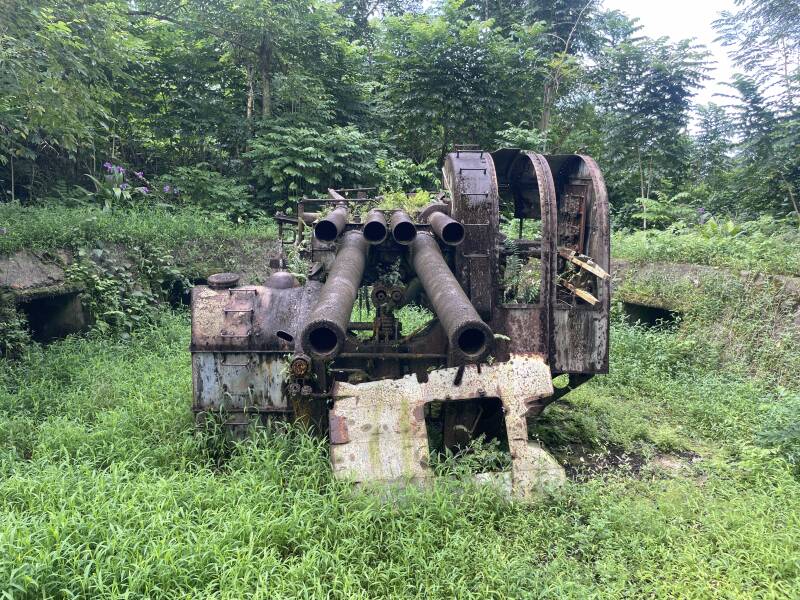
A row of tanks in the city of Kolonia.
The next day, my exploration continued, this time around the city of Kolonia. While scanning Google Maps, I was intrigued to see a marker for Japanese Army tanks right in the middle of the city. Curious, I followed the pin and eventually found them tucked away behind an unassuming industrial area. There, in a quiet row, stood a line of rusting tanks, slowly surrendering to time and the elements. It was a striking and unexpected reminder of Pohnpei’s militarized past, hidden in plain sight.

Another army tank, this time next to the Tourist Information Building

Except for the sign, the somewhat unassuming facade of the Tourist Information Building in Kolonia.
Further down the road, one tank was positioned rather curiously right next to the Tourist Information Office, perhaps a sign that the Pohnpeians take a certain pride in preserving this piece of history. It certainly offers something unique for visitors to see.
When I stopped by the tourist office to ask about tours, I found myself speaking to the staff through a small glass window, reminiscent of an old bank teller setup, with a pamphlet stand standing lonely in the foyer. I couldn’t help but wonder what kind of security concerns required that setup. But before I left, one of the staff members kindly came outside to meet me, handing over a list of local tour operators, an unexpected gesture that made the encounter feel much more personal.

Looking across the canal to one of the walls of Nan Madol.
Exploring Nan Madol: The Venice of the Pacific
Visiting Nan Madol was one of the most memorable parts of my time in Micronesia. This ancient and mysterious city, often referred to as the “Venice of the Pacific,” sits off the coast of Pohnpei, made up of over 90 man-made islets built atop a coral reef lagoon. Constructed from massive basalt stones and coral boulders, the ruins include remnants of temples, tombs, palaces, and homes that date back to between 1200 and 1500 CE. Like the Egyptian Pyramids, no one really knows how the heavy pillars were assembled to form the structures. Despite comparisons to Machu Picchu, Stonehenge, and Rapa Nui, yet remains one of the least visited UNESCO World Heritage Sites in the world.

The mangrove forest surrounds and permeates the ancient city, with waterways and islets within the mangrove swamp.


Inside one of the courtyards or buildings of Nan Madol.

Wading across the canal at Nan Madol; this was at low tide!
Since the tour was too expensive to do solo, I waited until the company found others to join, eventually teaming up with a German Swiss couple who, like me, were passionate about the Pacific. Their love for the region was clear, especially considering the long journey and multiple flights it took them to get there. One of the highlights was the walk through the mangrove forest to reach the site. There’s something about jungles that I find endlessly captivating, and this one didn’t disappoint. The entire experience felt like stepping back in time to a place still shrouded in mystery. As Pohnpei is well off the tourist trail, we only saw one other group at the site, likely diplomats or special guests, judging by their formal attire and entourage. Unlike us, they stayed on the far side of the canal, content to view the ruins from a distance. We came prepared wearing shorts and water shoes (with swimsuits packed for a waterfall swim later!) and waded through the knee-deep water to explore up close. Timing is everything when visiting Nan Madol; you need to arrive before the tide rises too high, or you won’t be able to cross on foot. Because of this, our tour itinerary was adjusted so that the stop at Kepirohi Waterfall took place after exploring Nan Madol. The drive itself was an insightful experience as we passed local farmers tending to their land and, rather unexpectedly, a man standing completely naked by the roadside, seemingly unbothered by our passing vehicle.
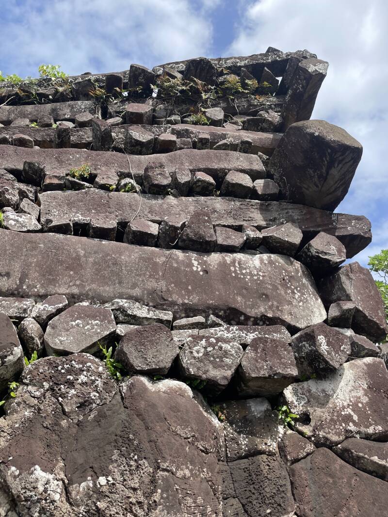
A detail of the stone pillars of Nan Madol.

Nan Madol was built between 1180 and 1200 AD. The sea level was lower when the city was constructed, and rising sea levels over time have contributed to the formation of the canals and islets within the mangrove environment.

Quintesssential waterfall selfie: Kepirohi waterfall
On our way back, we paused at several historical sites around Kolonia, the main town on Pohnpei. I’d already visited what I dubbed the ‘Tank Cemetery’, but somehow missed the hauntingly beautiful remains of the German Church.
It’s a surprising sight on such a remote Pacific Island, but its presence makes sense once you know the history. After the Spanish-American War, Spain sold several of its Pacific territories to Germany in 1899, including the Caroline Islands (which Pohnpei is part of), Palau, and the Mariana Islands (excluding Guam). Germany then administered these islands as part of German New Guinea, until Japan took control in 1914 during World War I.
The remnants of the church, just the belltower and a stone apse date back to 1909, when German and Spanish Capuchin missionaries built it during the colonial era. The rest of the structure was destroyed during World War II, and what remains is now partly reclaimed by nature, with vines and jungle reeds slowly overtaking the stone. It had a strangely cinematic quality, reminding me of that final scene in Logan’s Run, where characters step into a world overtaken by nature and time.

The German Church, built in 1909, during the German Adminstration Period.
A few days later, I discovered another fascinating relic while exploring the Pohnpei Botanical Gardens, walkable distance from my hotel. As one review aptly put it, “While some areas may show signs of neglect, the charm of the garden lies in its wild, untamed beauty, allowing nature to take centre stage.” And that was exactly the feeling I had as I wandered through the lush, overgrown pathways.

The Pohnpei Japanese Agriculture Station, built in 1926, in the grounds of the Botanical Gardens.
Hidden among the foliage was the Pohnpei Japanese Agriculture Station, one of just five buildings in the area to survive the World War II bombings. Built in 1926, this stepped-pyramid structure is a rare example of Art Deco architecture in the Pacific. It was designed by Yamashita Yasaburô, the foremost Japanese architect in the region before the war.
After WWII, the building was actively used by the Trust Territory’s Department of Agriculture, but it has stood abandoned since the 1970s. While some locals have proposed demolishing it to make way for a modern museum, there's growing interest in preserving the structure as a historical monument instead, an echo of a layered past slowly being reclaimed by the jungle.

Carlos, Santiago, myself and Viviana on our road trip. Picture credit: Carlos Roessler
The two main hotels in the area were just a short walk from each other and, unless you’re lucky enough to be invited into a local home for a meal, they offered the best dining options around. I often bumped into fellow travellers I'd met on my first day, a friendly German Swiss couple and an Ecuadorian couple, Santiago and Viviana. Santiago was working as an engineer at the U.S. Embassy, while Viviana, an architect, had joined him for the adventure.
Back in Palau, I’d crossed paths with another traveller, Carlos (a pseudonym), a German bloke staying at the same budget hotel. We discovered we were on similar routes and agreed to meet up again. Once reunited in Pohnpei, we rented a car and invited Santiago and Viviana to join us for a day of exploring.
Back at Sokeh's Ridge, exploring Japanese war ammunition further into the jungle.
One of our stops was Sokeh’s Ridge, the second visit for me, which we discovered was home to a hidden geocache. Carlos, an avid geocacher, was keen to find it, so we returned by car and hiked back into the jungle-covered ridge. Whilst we didn’t manage to locate the cache, traipsing through the long grass provided us with a jungle adventure; once again, a machete would have helped.

Guandong National Convention Centre Building in Palikir, the Capitol.
It doesn’t take long to circumnavigate the island, and before we knew it, we had arrived in Palikir, the capital of the Federated States of Micronesia. Like in Palau, the city’s government buildings and infrastructure appeared to have benefited from significant overseas investment, this time, largely funded by China. Palikir is home to the FSM National Capital Complex, a 135-acre site housing several government offices, including the FSM National Congress in its distinctive square building. The complex lies just off the main road, quietly tucked into the landscape. Unsure as to whether we were permitted to enter the building, Carlos took the first step inside the triangular Guandong National Convention Centre Building and we tentatively followed; the interior courtyard seemed like an oasis with shiny floor tiles and manicured Chinese gardens. It seemed a shame that we were the only ones there to enjoy the ambience. Then we found ourselves followed by some sort of guard or maintenance person, obviously checking on our intentions and realised it probably wasn’t open to the public.

Glistening tiles and Chinese Gardens at the Guandong National Convention Centre Building
By contrast, the Congress building just across the road felt far more inviting. The round structure welcomed us in, and we were immediately drawn to a group of women seated inside, carefully arranging flowers—likely in preparation for a formal occasion. A friendly woman came over to greet us and offered insight into the building’s unique design. Drawing inspiration from traditional Micronesian architecture, it featured details such as floor beams shaped like a Trukese canoe prow, and a central chamber built to symbolize consensus, with seating arranged to echo the layout used by the islands’ hereditary leaders. Even the grey pillars outside were a thoughtful reference to the stone columns of Nan Madol which I had previously visited.

In front of the Congress Building, Palikir.

Inside the Congress Building of Palikir.

Grey bricks in the cloisters surrounding the Congress Building, a reference to Nan Madol.
The Federated States of Micronesia is made up of three distinct islands, Yap, Pohnpei, and Chuuk. Each state is distinct, with its own unique culture, language, and ethnicity. While I would have loved to explore them all, the high cost of inter-island flights meant I focused my visit on just one: Pohnpei.

Sunset looking towards Sokeh Hill, Pohnpei.
Create Your Own Website With Webador